4.20.2008

Introduction

___________________________________________________
At the bottom of our globe we find the world’s fifth largest continent: Antarctica. Isolated, cold, dry, windy and white are perhaps the best words that characterize this foreign land. Its pureness is absolute, its size grandeur, and its inhospitable environment daunting.

"For centuries, Antarctica has been a land of inspiration through its exploration and science." Today, the National Science Foundation (NSF) funds and manages all US scientific research and support on the continent.

The Antarctic Treaty was signed in 1959, ensuring that the entire continent be reserved for peaceful purposes only. According to the NSF website, there are 46 nations who participate in this treaty, and of the 29 countries actively involved in field studies, the United States is the largest. At McMurdo Station alone, nearly 1000 people support the 300 scientists, or ‘grantees,’ in conducting over 80 research projects during the 2007/08 Season.

From October through February, Antarctica's austral summer, I worked for the Field Safety Training Program (FSTP), an integral part of the Science Support Center at McMurdo. With six members in our team, we were involved in assuring the safety of all field scientists through survival training programs, sea ice monitoring projects, deep field logistical planning and preparation, direct mountaineering assistance, and search and rescue response.

This position allowed me the opportunity to travel to a variety of locations throughout the continent, from the top of Mount Erebus, the southern most active volcano in the world, to the South Pole. Now that I have returned to the United States, i am continually asked, "So what was it like being in Antarctica?" My response: "It's the only place in the world where I felt as though I was a part of something bigger than life itself."


Welcome to my journey.


4.19.2008

Antarctic Facts

A Land of Ice_______________________________

With 5,500,000 square miles of land, Antarctica lies 1 1⁄2 times larger than the United States. Ice averaging 7000 feet thick covers 99.6% of the continental landmass, depressing major mountain ranges under its heavy weight, making them invisible to our naked eye. Because this ice also accounts for 70% of the world’s fresh water, if Antarctica’s ice sheets were to ever melt, ocean levels would rise over 220 feet!

Not only is Antarctica an extremely large, icy covered continent, it is also very high and dry. It averages in elevation around 7300 feet. The South Pole itself lies a little over 9000 feet at 90˚S. With snow accumulation of less than 4 3⁄4 inches a year, Antarctica’s air is remarkably arid, making it a perpetual white desert. Cold, bitter winds prevail throughout the year; blowing snow down its ice shelves and towards the sea, packing it into what becomes some of the densest snow in the world.

In September, Antarctica’s late winter, the size of the continent effectively doubles with the freezing of the sea ice, where it can extend to more than 600 miles away from the coast. Found between 60˚ and 40˚S is the Antarctic Convergence, or the Polar Front, where cold water from the south converges with and sinks under the warm water from north. This marks the limit of the winter pack ice.

Though the overall thickness of the ice varies, by March most of the annual sea ice has broken up and melted back into its original liquid state. Just like an ice cube that melts in water, frozen sea ice displaces the amount of seawater equal to its weight, so water levels do not rise as the sea ice melts. The natural fractures in the frozen ice also mark areas where seals and penguins can surface and create breathing holes throughout the winter.

Antarctica is geographically divided by the long Transantarctic Mountain Range, distinctly separating Eastern Antarctica (or ‘Lesser Antarctica’) from Western Antarctica (‘Greater Antarctica’). Within this range is the highest point of the continent, Mt Vinson, standing at 15,680 feet.

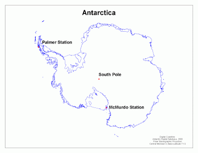
Also of geographic significance, is the Western Antarctic Peninsula, which separates the two great embayments of the continent, the Weddell and the Ross Seas. Each of these has their own ice shelf, the Ronne and the Ross Ice Shelf respectively, with both extending of the great Antarctic ice sheet. The Ross Ice Shelf, roughly the size of France, is the world’s largest. It converges with the sea (or the sea ice during the austral winter), directly in front of McMurdo Station. Though its mean thickness is between 1000 and 2250 feet, its significantly less where it meets the Ross Sea, only around 320 feet thick. It’s amazing to think that these ice shelves are actually floating!


(click on image for larger view)


4.18.2008

McMurdo Station


Located at the southernmost tip of Ross Island is Antarctica's largest science base, McMurdo Station. Built on New Zealand's Antarctic claim, McMurdo has been a polar base for American scientists and support personnel for over 50 years.

Historically, Ross Island is known as the jumping-off point for polar exploration ever since Ernest Shackleton and Robert Scott began their race to the South Pole in the early 20th century. Today, according to Texas A & M University, Ross Island is the farthest-south landmass accessible by ship, making McMurdo's harbor the world's southernmost seaport.

Volcanically formed, Ross Island's geologic and geographic features pose unique challenges in sustaining a year around polar science station. Its western shoreline opens to McMurdo Sound, a 2500 mile expanse of the Ross Sea. All but 10% of the Sound's total shoreline freezes annually with nearly 10 feet of sea ice. On Ross Island's southern border, is the Antarctic polar plateau, which brings strong katabatic flows into McMurdo Station itself. These winds bring temperatures that range anywhere between -59˙ - 30˙F (without wind chill).

These factors combine to make the air support into McMurdo Station very strategic. Every August, a frozen airstrip is built on the smooth annual sea ice. Rising temperatures however, will force its relocation up onto the McMurdo Ice Shelf. Here, the 500 feet of glacial ice can withstand the remaining temperature fluctuations prevalent throughout the remainder of the polar austral summer. So, why don't they build the runway on the ice shelf to begin with? The sea ice runway is not only closer to McMurdo Station but it also takes several weeks to successfully lay a 10-mile long fuel line out to the new airstrip.

4.17.2008

Arrival

(Click on any image to enlarge)


A C17 air force plane transported us for the 5 1/2 hour flight from Christchurch, New Zealand to McMurdo Station, Antarctica.


The intricate ceiling inside.


A view of the people and the cargo transported on our flight, taken from the upstairs 'cockpit bubble.'


My first view of the Antarctic continent.


All of the gear needed for our 5 months in Antarctica is issued at the division headquarters in Christchurch, NZ, including these cold-weather 'Bunny Boots.'


The almost surreal experience of touching foot in Antarctica.


The crowded Terrebus transport to McMurdo Station itself.


From the moment I arrived, I felt like I stepped back in time to a mining town back in the early 20th century.


My first experience of the cold winds that whip down the Antarctic Ice Shelf into McMurdo Station. They are enough to freeze your skin instantly, and penetrate any clothing that is not truly windproof.


Happy Halloween! Just one of the many parties held throughout the season.


4.15.2008

Monitoring Sea Ice Depth

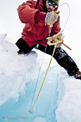
During Antarctica's austral summer, the depth of the annual ice pack must be measured at least twice weekly to ensure the safety of all traffic. When the sea ice melts to less than three feet thick, it will be closed for the season.


Inside the Hagglund, our sea ice vehicle.


The typical Antarctic scene, the only colors being white and blue, and the 'BIG RED' of our issued cold-weather jackets.


The Hagglund parked in front of the Barnes Glacier.


Sea ice fractures start off small, then heal themselves as the Ross Sea fills in the crack and refreezes. The fracture will open again, then freeze again, sometimes so often that the size of the fracture can eventually become over 30 feet wide.


These large fractures are measured in depth throughout the season. First, a trough is shoveled out perpendicular to the fracture.


Then a whole is drilled at each location that a fracture had once opened.


Sometimes the depth of the fracture is amazingly deep.


But, when the depth of the ice reaches 1 meter, or only 3 feet thick, travel on the sea ice outside of McMurdo station is closed for the season.


4.12.2008

"Happy Camper" - Winter Survival Training

Before any scientist or member of science support travels outside of the McMurdo area they must attend a winter survival course. Here, teams of 12 to 20 individuals will work together to establish an overnight camp on the McMurdo ice shelf during potentially challenging weather conditions. They will learn how to build a variety of snow shelters, cook themselves dinner with small backpacking stoves, and experiment with many of the tricks used to successfully sleep warm during an unexpected Antarctic survival situation.


This happy camper is intricately trimming the sides of snowblocks used to build a snow wall around camp. These walls best secure tents from being destroyed by the vicious winds that rip down Antarctica's ice shelves and glacier valleys.


Digging out the entrance is the last step in building a "quinzee," an Inuit word meaning snow shelter. This type of crude snow cave is made simply by hollowing out a mound of snow.


4.11.2008

Weddell Seals

The Weddell seal is the most southerly living mammal in the world. Spending most of its time on fast-ice, frozen sea ice attached to the coast, the Weddells uses tidal cracks for breathing holes. They keep these holes open by sawing at the ice with their upper incisors and canine teeth and by swing their head from side to side. Their live expectancy is based upon longevity of their teeth, up to 20 years.


Female Weddell seals, called cows, are slightly larger in size than the bulls and can grow up to 11 feet long and weigh up to 1200 pounds.


Mating season for the Weddell seal occurs only weeks after the previous years pupping season. Implantation however, will occur over three weeks later, allowing for the cow to direct all of her energies towards milking her current newborn.


Pregnant cows begin gathering at traditional pupping areas as early as late August. In latitudes as far south as the McMurdo area, peak pupping time occurs in late October into November. At birth, pups weigh around 60 pounds and fatten quickly on their mothers 42% fat milk. Though twins are very rare, it isn't uncommon for one mother to adopt an abandoned pup (as in this photo).


Lactation lasts for up to 50 days when the pup may weigh up to 220 pounds. While the mother nurses, she will not feed, causing her to loose a significant percentage of her body weight in order to best protect her pup. Although Killer whales are the Weddells primary predator, Leopard seals are also known to kill the pups.


At birth, Weddell pups have no insulating blubber, but they do have very fine, thick baby fur, called lunago. At two weeks the pups begin to loose this grey natal coat and will molt over the course of a month into a coat similar to the adults.


Vibrissae, or whiskers, are very important to seals. With many nerve endings at their base, vibrissae are extremely sensitive to motion. This is important as visibility diminishes with depth and the detection of prey movement by the Weddell is determined by the feeling of subtle changes in the fishes motion instead of by sight.


4.09.2008

Adelie Penguins

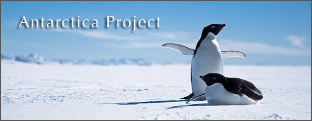
Along with the Emperor penguin, the Adelie is the only other truly Antarctic penguin. Unable to tolerate air temperatures greater than 20˚C, the Adelie is restricted to colder waters, breeding further south than any other penguin.


The most abundant of all penguin populations, the Adelie numbers close to 2 1/2 million pairs throughout the Antarctic continent. Half of this number are found in the Ross Sea alone. Here at Cape Royds, only 20 miles from McMurdo, over 2000 penguins return each November to mate. Due to the short summers, their breeding cycle is brief, occurring only during the few weeks when temperatures are above freezing and food is abundant in open water found near by.


The annual mating period is extremely noisy as males compete by building rocky nests and calling to females who are searching for a chosen place to lay their eggs. Flipper waving, guttural gossip, and pebble thievery best characterize their annual courtship. Such socialization dies down quickly as eggs are laid by late November and are incubated for 32-37 days. The Adelie penguin will lay two eggs each, but only one can completely fit underneath the birds breast. Many times the outer egg is sacrificed to predators, such as the mightly Skua (the Antarctic sea gull), for the successful incubation of the better protected second egg. Fledging takes 41-64 days, and by three weeks a creche (or pack) of chicks form. By mid February, adults will leave their young and the chicks will gradually move sea. Mortality rate can be quite high, over 35% will not make it to open water. If they survive for the first two to three years, Adelies can live to be 10 - 12 years old.


Both males and females take turns laying on the eggs in between their frequent journeys to the sea for food.


Their travels to the sea ice edge can be tricky as Adelie penguins must negotiate the cracks that form between the sea ice that is fixed to shore and the annual sea ice. These fractures repeatedly open and freeze close from the changes in tides, swells, winds, and temperature.


Many times single penguins will break off from the rest of the pack to find their own way to the sea. Some penguins even have an inner urge to completely leave the rookery and venture to places that no one will never know.


The Adelie penguin's diet consists mainly of ice krill which lives in the shelf waters along the continental edge. Though the penguin can dive up to 450 feet deep, most of their food is caught close to the surface.


Adult Adelies reach a height of approximately 30 inches and weight close to 11 pounds. Male and female penguins share the same physical markings and can only be distinguished by their slight difference in size. Early explorers originally classified these penguins as fish, however, these birds are actually well adapted for their job, to fly in water. Their wings have been reduced to paddles, with the bones flattened. Their wrist and elbow joints fused, so their wings cannot be folded, thereby acting as powerful propellers in the water. Their cruising speed averages four and a half miles per hour. Their feathers are reduced in size and stiffened, with a downy insulating layer at the base which traps air over their thick blubber and skin. Their heads can also retract to make them amazingly hydrodynamic in shape. They use their legs, which are well set back on their body, to rudder their movements while underwater. On land, penguins waddle with a rolling gait and toboggan themselves on the ice and snow to rest their short legs.


No land predators make the Adelie penguin one of the most curious and humerously vocal animals humans can encounter on the ice. There is no wonder why this bird is one of the most classic representatives of the Antarctic continent.


4.07.2008

Mount Erebus

Two snowmachines are dwarfed by the terminus of the Barnes Glacier, one of the many iceflows that roll off of the massive Mount Erebus (seen in the background). It stands at 12,447 feet in elevation and is the southern most active volcano in the world.


Looking west off the shoulder of Mt Erebus lies the sea ice edge and the Royal Society range, approximately 60 miles away. The last point of land seen in the foreground of this photo, on the lower right before open water, is Cape Royds. Every year, over 1000 mated pairs of Adelie Penguins use this point as their birthing grounds.


In late November, McMurdo's primary search and rescue team performed a training exercise on the northern side of Mt Erebus and snowmachined to the only scientific station on the mountain, the Lower Erebus Hut (LEH). Familiarization of this route is significant because stormy weather can delay helicopter access onto the mountain for weeks at a time. The following photos capture the incredible cloud formations that formed as a stormfront moved in. By the time we reached LEH, winds were exceeding 30 knots and temperatures were hovering around -25˚F.


Snowmachine mechanic Bob Sawicki helps to switch out jets in the fuel line at 8,000 feet in order to improve the machine's performance at higher elevations on Mt Erebus.


The Lower Erebus Hut sits at 11,500 feet on Mt Erebus' caldera rim. Currently, 5 scientists are stationed here and are involved in seismic and radar studies of the volcano, monitor its gaseous outputs, and research the geophysics of its magma and crystal formations. When looking inside its crater rim, two active lava lakes can be seen, making Mt Erebus one of only three active volcanic mountains of its kind in the world. Since the other two exist in politically unstable regions of Africa, Mt Erebus has logistically become the simplest to study.


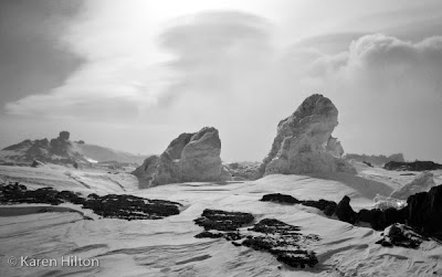
These ice towers, geologically called fumaroles, mark a point were hot gas is released from old lava flows. Ice caves form underneath the snow with tunnels that link a series of beautiful crystalized rooms.


Down we go into the first fumarole...


A distinct line of blowing snow on the horizon denotes an area of strong winds we will soon enter as we descend the mountain.


Visibility diminishes quickly as we enter into a ground storm with strong winds and blowing snow.


Alex Gerst is a German scientist who specializes in radar studies of volcanic lava lakes around the world. Stationed out of LEH, this is Alex's third year studying Mt Erebus.


Looking across the sea ice to the Royal Society Range 14 hours after leaving McMurdo.